Wellhead Protection (WHP)
Nebraska’s Wellhead Protection Program (WHP) is a voluntary program which assists communities and other public water suppliers in preventing contamination of their water supplies. The Nebraska Legislature passed LB 1161 in 1998 (Neb. Rev. Stat. §46-1501 – 46-1509) , authorizing the Wellhead Protection Area Act. This Act sets up a process for public water supply systems to use if they choose to implement a local Wellhead Protection plan. The Nebraska Department of Water, Energy, and Environment (DWEE) is the lead agency for Wellhead Protection (WHP) Plan approval.
The goal of Nebraska’s Wellhead Protection Program is to protect the land and groundwater surrounding public drinking water supply wells from contamination. Since approximately 85% of Nebraskans receive their drinking water from groundwater, preventing groundwater contamination is vital.
Publication
Keeping Your Water Safe – The Groundwater Foundation 2009
Plan
The Wellhead Protection planning process includes identifying the land surrounding the public water supply wells to be protected, identifying potential sources of groundwater contamination within this area, and managing the potential contaminant sources. Emergency, contingency, and long term plans are also developed for the community water supply, all the while educating and involving the public.
Database
Wellhead Protection Status – DWEE
| List - Approved WHP Plans - DWEE 02/2025 | Approved Plans by PWS.pdf (46 KB) | Approved Plans - by Date.pdf (46 KB) |
Publication
WHP Area Management Planning Manual – The Groundwater Foundation 2008
Steps
1.) Delineating the Wellhead Protection Area
A Wellhead Protection area is calculated from information such as the geologic material the well is drilled into and the annual pumpage of the well. Computer-generated flow lines depict the approximate path groundwater, or a contaminant in groundwater, will take to reach a well. Flow lines are then associated with estimated times-of-travel and a boundary is drawn on property lines enclosing all 20-year-flow lines. The Nebraska Department of Water, Energy, and Environment (DWEE) provides these maps at no charge.
To view or download the statewide Wellhead Protection Area dataset, visit NebraskaMap.
To request a copy of a map, please email us: DWEE.moreinfo@Nebraska.gov or call 402-471-3376.
A Wellhead Protection map is just a piece of scrap paper unless a community enacts local ordinances, county zoning, or voluntary activities within its Wellhead Protection Area.
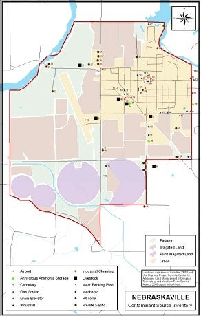
2.) Potential Contaminant Source Inventory
The purpose of a potential contaminant source inventory is to identify potential contaminants that may pollute groundwater. Inventories should be compiled from existing databases and on-the-ground observations. Contact the DWEE Wellhead Protection Program for spreadsheets and shapefiles from existing databases.
Main Requirements
- Inventory completed/updated within the past 3 years
- Contaminants marked on a map (point sources)
- Spreadsheet associated with point source contaminants
- Land use map (non-point sources)
Databases Available
- DWEE – Interactive Mapping System – Contact DWEE WHP Program for shapefile (GIS file)
- DWEE – Registered Water Wells
- State Fire Marshal’s Office - flammable and hazardous waste storage – Contact DWEE WHP Program
- NRDs - abandoned wells – Contact your local NRD
- NE Oil & Gas Conservation Commission - Oil & Gas Wells
Common Potential Contaminant Sources
Agricultural
- Fuel Storage
- Grain Storage
- Water Well
- Chemigation
- Livestock
- Chemical Storage
Commercial / Light Industry
- Auto Repair
- Dry Cleaners
- Fuel Stations/Storage
- Machine Shop
- Rail Yard
Industry
- Manufacturing
- Gas/Oil Well
- Junk Yard
- Landfill
- Sewage Treatment
Other
- Cemetery
- Golf Course
- HWY Maintenance Yard
- Transportation Corridors
- Etc.